S4A Smart VIEW+ is an advanced flight-tracking solution providing our customer airlines with opportunity to improve their operational awareness by tracking, monitoring and analysing events that can disrupt flight operations. Smart VIEW+ provides real-time visualization and monitoring of the airline’s fleet. The progress of each flight can be observed on an interactive map. Also, aeronautical, geographical and weather data display and organization tools are built into the product making it a complete and comprehensive Flight Following and Flight Watch solution for both flight dispatch and management users.
S4A Smart VIEW+ can be integrated with 3rd party weather data providers (e.g. DTN) and/or internal airline, or external free, weather sources for optional display of additional layers such as:
- Radar weather
- Satellite weather
- Volcanic ash
- Turbulence
- Sigmets
- Airmets
- Icing
- TAF/METAR
- Lightning
- And much more…
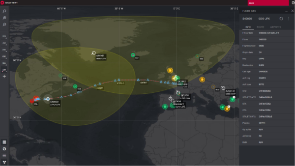
There is also a possibility to integrate with FlightRadar24 to receive the actual aircraft positions and traffic. Plus the program supports Airport view in combination with ADS-B.
Key Features:
- Flight tracking (ACARS position reports and ASDI data), including other airlines
- Full situational awareness
- Easy access to flight related information and overlay objects: Airports, Runways, Approach aids, Airport facilities information, Navigation aids, Flight status (airborne, taxi, diverting, emergency, holding, etc.) Alerts, Airspace (FIR/UIR, Alert, Danger Military, etc.), Airways/routes, Timezones, Weather, ETOPS information (circles, rules, entry/exit/critical points, etc.), Fuel status information, oceanic tracks
- Integration with different 3rd parties WX providers (METAR, TAF, SIGMET, AIRMET, SigWX, UAD, Icing, Satellite, Radar weather, volcanic ash, Aviation Cloud Ceiling, Cloud-to-Cloud Lightning, Dew Point, Global Turbulence, etc.)
- Visual airplane alerts (lack of position report, deviation from planned route, etc.)
- Weather and NOTAMs alerting
- Bookmarks management
- Custom areas layer management
- Different background maps available (including 3D earth view)
- Decision support
- Distance calculator
- Messaging
- Useful toolbars, labels and floating detail windows
- Access to all other operational data including: Crew/passenger information, Flight plan, MEL
- Integration with other Smart4Aviation products