Articles
| Name | Author | |
|---|---|---|
| WHITE PAPER: Making better informed decisions about weather | Guy Maylatt, Aviation Product Manager, Tomorrow.io | View article |
| CASE STUDY: A new Weight & Balance, Takeoff, and Landing Runway Performance solution at Kalitta Charters II | William Pletzke, Director of Safety, Kalitta Charters II | View article |
| CASE STUDY: MYAirline builds the right foundations for success | Capt. Dharmaraj Naiker, Director of Flight Operations, and Capt. Kuhan Ananthavadivel, Head of Safety and Quality, both at MYAirline | View article |
| CASE STUDY: Taking basics to the next level at Frontier Airlines | Casey Meeks, Technical Standards Captain, Frontier Airlines | View article |
| CASE STUDY: A digital solution for greater flight efficiency | Frank Appeltrath, Head of Flight OPS & Support, AeroLogic GmbH and Vincent Toegel, Fleet Chief B777, AeroLogic GmbH | View article |
WHITE PAPER: Making better informed decisions about weather
Author: Guy Maylatt, Aviation Product Manager, Tomorrow.io
SubscribeTomorrow.io has a wholly new approach to the delivery of weather information: not just a forecast but insight into how to deal with the weather
While the main purpose of this article is to share with readers current features and upcoming cutting-edge developments, we’re making to Tomorrow.io’s aviation offering, it might first be useful to provide some background information about our business.
TOMORROW.io
Tomorrow.io is the world’s leading weather and climate security platform.
Founded in 2016 by former Israeli Air Force pilots who had first-hand experience with the impact of weather on flying, Tomorrow.io has now been in business for seven years. Originally established with the objective of solving weather problems at all levels from observations to software applications, Tomorrrow.io has always striven to solve fundamental problems encountered with weather. Those problems vary in different parts of the world but, for the developed world, it is about how to understand when, for instance, will the rain arrive or when will lightning strikes occur. For the less developed parts of the world, the challenges posed by weather are much greater, especially in sectors such as agriculture. At the outset, the business was verticalized, supplying sensors to work with, for instance, the Internet of Things (IoT) and building the appropriate models to leverage the information gathered by those sensors.
THE CHALLENGES POSED BY WEATHER
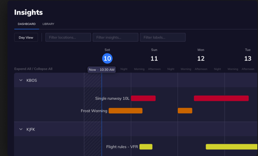
Most weather forecast models in the world today are government driven: they are fine for basic weather information but little more. At Tomorrow.io, we have developed our own proprietary model addressing the issue of what weather-related information should be available wherever you are in the world and what users can do with that information. Tomorrow.io applications don’t only provide the data itself and what the weather conditions are going to be; we provide weather intelligence – complete with predictive insights (figure 1) and automated alerts, our platform provides recommended action so aviation organizations can stay safer and operate more efficiently in advance of weather impact.
At the most basic level, when users see a weather forecast, they just see the numbers whereas what they really want to understand is how that should be reflected in their decisions and subsequent actions. This is where Tomorrow.io applications perform well taking a specific weather condition and transforming it into a useful and appropriate idea for action.
In aviation, there are certain procedures that are reactive to specific weather conditions: what Tomorrow.io does is take those conditions, such as high winds at a given velocity, and show them on a graphical view with a timeline that can be sent as an alert to recipients for whom it will be relevant so that users know when they will meet those conditions.
Importantly, Tomorrow.io is not there to replace professional meteorologists. On the contrary, our technology empowers METAR (Meteorological Aerodrome Report) users to extend their capabilities. Once a professional meteorologist is using the platform, their capabilities will be enhanced by the application of their professional skills to the best information available.
THE PROBLEMS WITH WEATHER FORECASTING TODAY
There are many problems with legacy weather systems but most of those problems relate to the fact that sensors are mainly government owned and controlled, meaning that most weather Apps and solutions are based on the same governmental data. As part of the delivery of a suite of enhanced services, Tomorrow.io is launching its own Satellites that will offer a global coverage which is not available today. So, when an aircraft is flying from London to New York, there will be good weather forecasts for the UK area but, as the flight gets to the central Atlantic, it will have to rely on some old and, possibly, not updated forecasts derived from government satellites in high orbit. The satellite might not have been over the relevant area for hours or even days and the forecast might say to expect to encounter cloud but not the altitude of that cloud, what type of cloud it is, does it contain ice particles, is there turbulence associated with it… all information that the pilot would want to know. It can get to a point where a pilot has to rely on the aircraft’s radar which has similar limitations. It will show weather but not what it will be possible to do about it, say pass on the right or left or go above it.
So, what airlines do in order to be able to deal with that is, they take a lot of extra fuel onboard to give them the time to decide. They are very reliant on reports from other aircraft in the area. The problem with that extra fuel is that a large part of it, about ten percent, usually goes to waste. Of an extra tonne of fuel uploaded just to allow the time for that decision-making process, 100kg will be simply vaporized, plus the extra weight of that fuel makes the flight more expensive and less efficient. In a worst case, it can even make the aircraft so much heavier that it cannot cruise at the ideal level.
All of that can be solved if pilots have access to the same quality and detail of weather information everywhere that is available in the continental areas like Europe and the USA. This is what Tomorrow.io envisages; the ability to have, at every point on the globe, low-orbit satellites at intervals of about 90 minutes that will be able to deliver higher quality weather information than high-orbit satellites and will be able to tell pilots what alternatives are available to them in order to avoid bad weather. This will be our greatest contribution to the industry.
WHAT WE ARE DOING TODAY
Some things that Tomorrow.io is doing already is checking the government-driven weather information that everybody uses but using our applications to provide more useful weather intelligence. For example, when there is lightning at an airport, usually it means, depending on the proximity of the lightening, that take-offs and ground operations might have to stop. Normally proximity is checked visually to see how close the lightning is as the basis of deciding what to do. However, once Tomorrow.io has the lightning data in its software, it can be connected to the solution’s alerting abilities (figure 2), the live map, and all of the high-end infrastructure of the system so that users can draw circles of reference around the relevant airports, not only what strikes have happened but also to identify when the lightening will have cleared inside a specific radius.
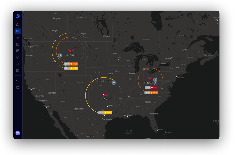
This is what airlines need. It’s called an all-clear timing because the regulators have defined specific processes that derive from that all-clear timing. After lightning has cleared that area for ten minutes, airlines can continue their routines and procedures as usual. Tomorrow.io provides significant support for that and for other cases such as icing and high winds.
KEY FEATURES
Our new solution embraces all the above, weather intelligence and weather insights, as an assistant in a decision-support tool in the main areas of priority for airlines: flight planning and flight monitoring. How we will achieve that is by first adding to the platform’s basic winds and temperatures, up to 55,000 ft, turbulence forecasts, icing, and Cbs (those dangerous Cumulonimbus clouds to be avoided when flying). All of that package, based on government data, is the basic information that you’d want when planning a flight and is usually not in real-time but uses forecast models. In the new Tomorrow.io system, all of those layers of information will be available but for 36 hours ahead which is the most relevant time for planning flights. A flight can be planned with all the relevant data at all levels so, hopefully, the airlines will be able to plan a route from A to B at all levels in three dimensions plus time (figure 3), with every part of the route then being monitored.
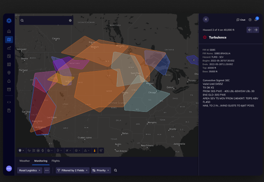
That means, for example, that, for the first time, the airline can build onto the Tomorrow.io infrastructure the ability to alert them when specific conditions are met and in three dimensions. A user can plan 100 routes, upload them to the platform and identify the ones that are prone to turbulence.
One of the problems for airlines in the planning process is simply the amount of data that needs to be taken into account by all parties to the flight. For a flight such as Israel to England there might be a 30-page flight briefing of which 25 pages would be weather data; a lot of data to be consumed for each decision by the pilot. We have set out to design a solution that brings it all together and only alerts the pilot when there are problems ahead, management by exception. Of course, the three-dimensional top-level display is not new but what is new is that in addition to that is Tomorrow.io’s insights engine’s ability to offer decision support plus, we can provide our own proprietary data models. For example, we have a state-of-the-art model for ground-level forecasting which we have called 1Forecast, which some US and South American airlines are already using and which provides better value than any other model at ground level. It offers users the edge inasmuch as, even though an airport might say that it will be open by, say, 09:00 because the fog will have cleared by then, the Tomorrow.io report might say that it will be clear 07:00, which gives the airline has an additional two hours to plan and being two hours ahead of that government data can mean a significant amount of money for an airline.
COVID-19 AND TRAINING
In the period following a pandemic, anything that can make decisions easier is always going to be welcomed. But that was also appreciated during the period of the recent Covid pandemic. In that time, Tomorrow.io focused efforts on the logistics sector which was much busier. With cargo aircraft, as with any aircraft, better weather information with decision support will still save time and money. Also, in the US, domestic aviation during Covid was not that badly hit but the Tomorrow.io solution that helped them to be more efficient, for example, knowing when to de-ice an aircraft, was very much appreciated.
The Tomorrw.io solution is designed to not need elaborate user training. Users can simply onboard it and start. With the large numbers of new people joining the industry post-pandemic, an intuitive solution that doesn’t need time spent training it will be very useful. Equally, for the established professional user, training is not needed. But even where people might need some introduction to the solution, they will very quickly get to grips with it and how to use it to their advantage. Weather is a key factor in aviation and the availability of an intuitive solution that also supports faster and better-informed decisions about weather and dealing with it offers airlines and operators a major advantage (figure 3).
REGULATIONS AND REFLECTIONS
As far as regulations are concerned, if Tomorrow.io is to be useful for airline and operators’ headquarters, it will need to take account of regulations. There are two processes underway in this regard. First of all, we are aiming to become a certified meteorological service for airlines, meaning that we’re aiming to have the ability to sell a met service as EWINS (Enhanced Weather Information System) certified so that airlines will have Tomorrow.io mets certified by the FAA to, for example, provide TAFs (Terminal Aerodrome Forecasts) and to do everything that the HQ workflow involves.
The second process is that Tomorrow.io is building a CWIC ability, CWIC is the commercial weather information provider. There is a basic governmental package that offers a minimum requirement with which weather tools can work and which the planning system needs. Usually, when those planning tools are designed for flight trials, it is simply necessary to get that weather data package. At Tomorrow.io, we are working to push that data as fast as possible, which also involves a lot of regulation because, when that is done, it is required to maintain redundancy between jurisdictions plus we need to retain specific latency definitions for times and publications so we need to be strict with regulations. For example, on the Tomorrow.io platform, for every airport you click, you’ll get the METEO (Meteorological) and the TAF with the observation forecasts of the aerodrome. In order for Tomorrow.io to be able to say that this is a METAR Meteorological Aerodrome Report) and a TAF, we have to ensure that we are retrieving them from the right, official government source, which we do.
Working with customers’ processes
An airline or operator implementing Tomorrow.io does not have to change any processes for the solution to work but we hope that they will because we want to save them time. For example, in any airline there will be a set of procedures that are tied to specific weather conditions. What Tomorrow.io can provide is that, when the user gets that weather condition alert, the alert already includes the relevant procedure material as an attached file. So, using the solution properly can save some time but that will be most effective if users do adapt some processes in order to access the best benefits.
FUTURE PLANS
The biggest development in the near future will be launching the satellites as planned and having that global coverage in the system that is relevant and applicable for every airline that wants the data. That will save lots of money and even lives if it’s properly used, and that is our vision. In the long term, given that we are now seeing ground operations, meteorologists, and dispatchers as well as flight planning and monitoring using our solution, looking two or three years ahead we should be able to also have a real impact in the flight deck where Tomorrow.io’s capability as a weather decision-making tool will support some of the most important decisions being made in the flight deck where decisions usually involve safety. Our processes can assist in decisions such as where to land in an emergency faced with up to ten alternative airports, to decide which will be safest.
As I stated earlier, we are just at the start of our development journey but I hope that, in this article, readers have learned something useful about our service.
Contributor’s Details
Guy Maylatt

Guy Maylatt is Tomorrow.io’s Aviation Product Manager. With 15+ years of aviation experience, Guy draws on deep industry expertise to drive the discovery, planning, and development of all aviation features and functionalities. He has served as a commercial airline pilot (Boeing 737) for EL AL Israel Airlines and a military search and rescue helicopter pilot (UH-60) in the Israeli Air Force. Guy lives in Tel Aviv, and enjoys sous-vide cooking and spending time with his family when he’s not thinking up new aviation innovations
Tomorrow.io

Tomorrow.io is the world’s leading Weather and Climate Security Platform, equipping humanity with the weather intelligence needed to thrive in an era of climate crisis. Through predictive and actionable insights, customers like JetBlue, Delta, the U.S. Air Force, and more use Tomorrow.io to improve safety, efficiency, and sustainability by adapting to weather-related challenges at scale.
Comments (0)
There are currently no comments about this article.
To post a comment, please login or subscribe.