Articles
| Name | Author | |
|---|---|---|
| CASE STUDY: Japan Airlines gets new turbulence mitigation solution | Hide Ametani, B787 First officer, Japan Airlines and Hagay Makov, VP Business Development, SkyPath | View article |
| CASE STUDY: Better Weather for British Airways’ Pilots and Dispatchers | Alex Lane, Senior First Officer, British Airways | View article |
| CASE STUDY: Discover Airlines transforms Flight Operations with advanced eSIM connectivity | Jonas Becker, EFB Administrator, Discover Airlines | View article |
| CASE STUDY: Air Caraïbes and French bee step up to the latest flight planning | Justinien Lelion, OCC Flight Ops Engineer, Air Caraïbes | View article |
| CASE STUDY: Cathay Pacific opts for digital fueling solution | Captain James Toye, Head of Line Operations, Cathay Pacific and Robin Weissgerber, Product Strategist, Information Design | View article |
| WHITE PAPER: Beyond the Checklist | Klaus Olsen, EFB Admin Services, CEO/EFB Administrator | View article |
CASE STUDY: Japan Airlines gets new turbulence mitigation solution
Author: Hide Ametani, B787 First officer, Japan Airlines and Hagay Makov, VP Business Development, SkyPath
Subscribe
Hide Ametani, B787 First officer, Japan Airlines and Hagay Makov, VP Business Development, SkyPath share Japan Airlines’ turbulence warning upgrade journey and gains
Hagay Makov
Before we go into the case study itself, we’ll first introduce readers to SkyPath and how it works. And then Hide will introduce Japan Airlines and who they are. We’ll then cover the airline’s experience with SkyPath from their perspective.
SKYPATH
SkyPath is a crowdsource platform, mapping the sky with real-time Turbulence reports. Just like Google Maps or Waze, the navigation apps you are probably familiar with. Crowdsourcing is a way to leverage the experience of everyone who flew your route before you. SkyPath, a software-only solution, gives Pilots and Dispatchers complete Turbulence visibility, for better situation awareness.
In figure 1 you can see how SkyPath works. Once SkyPath is downloaded to the pilot’s iPad, it turns the iPad into a Turbulence sensor, using its accelerometers and a patented algorithm. Whenever the aircraft vibrates, the iPad vibrates with it. The information is uploaded to our servers and goes through a/c type normalization and noise filtering (filtering out anything that is not turbulence – for example: tapping on the iPad, or if it was held by hand and moved around). Once the data is pure turbulence, it is anonymized and shared throughout the SkyPath ecosystem for all users to see. For a single location we may have one report or 1000 reports. Additionally, sometimes there are two iPads in the cockpit; SkyPath can validate the information at the server level and see that both iPads get the same result.
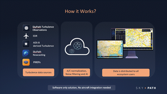
Figure 1
If there is no connectivity, pilots will get the information on the ground, before they take off. SkyPath will generate information and pilots will get notifications for encountering turbulence and, once they land and regain connectivity, their turbulence reports will be automatically uploaded to SKyPath servers, and the information will be shared with the entire ecosystem.
SkyPath has accumulated data from thousands of flight hours. Figure 2 gives some numbers for SkyPath use and activity.
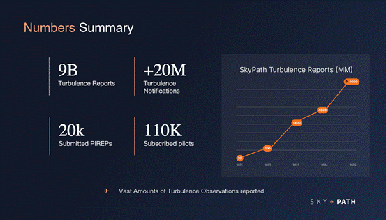
Figure 2
In the past year, SkyPath generated 9 billion turbulence reports for users, covering turbulence events from smooth to severe. Smooth is reported because SkyPath found that pilots want to know where there is no turbulence, not only where they can avoid turbulence. SkyPath provided customers with 20 million notifications. The app automatically looks 100 miles ahead and notifies the pilot vocally and visually that he is heading towards turbulence. SkyPath also generated 20,000 PIREPs to its community. SkyPath has been approved to officially submit and receive FAA PIREPs. There are 110,000 pilots subscribed to the system and almost 32,000 users flying daily with the application. The growth in SkyPath users is very clear. You can use the standalone app or the integrated version with other EFB providers, Jeppesen, Lido, AVIOBOOK and more.
Hide Ametani
I’m going to look at three things. One, how SkyPath is rapidly growing; two, how Japan Airlines uses SkyPath in our daily operations; and three, how SkyPath has helped Japan Airlines become safer and more efficient in our operations. But first, a brief introduction to Japan Airlines (JAL).
JAPAN AIRLINES
Founded in 1951, JAL operates, as you can see in figure 3, out of Tokyo, Haneda and Narita with a fleet of more than 150 aircraft flying to Europe, the US and in the APAC region.
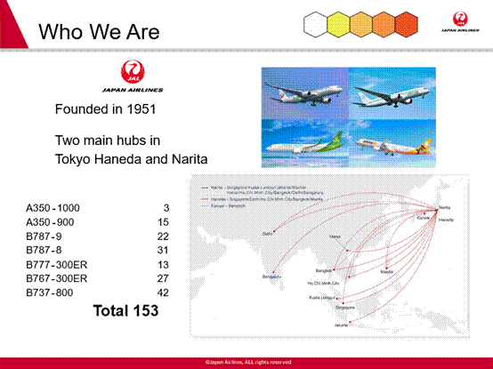
Figure 3
USING SKYPATH IN JAPAN AIRLINES
Figure 4.1 covers the domestic area of Japan. As you can see, there’s a lot of data generated and this is just an hour of data.
Figure 4.1
Figure 4.2 shows the Pacific Ocean with a lot of traffic coming into Japan as well as going out.
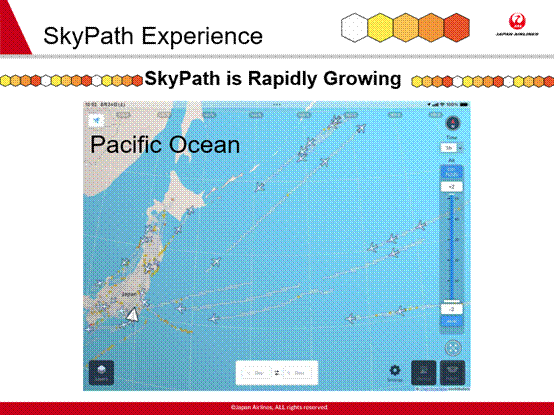
Figure 4.2
We rely on our own airline data, but we also use data from other airlines such as United, Cathay and Zipair, one of JAL’s subsidiaries. Figure 4.3 shows Europe where, compared to just a year ago, there is so much improvement, so much more data that we can use.
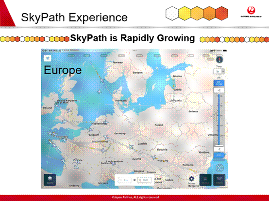
Figure 4.3
We usually fly across South East Asia, as in figures 4.4 and 4.5, when coming back from Europe into Japan; but JAL also serves destinations in those countries.
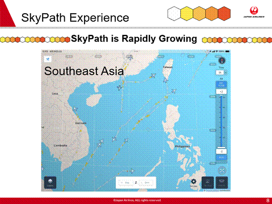
Figure 4.4
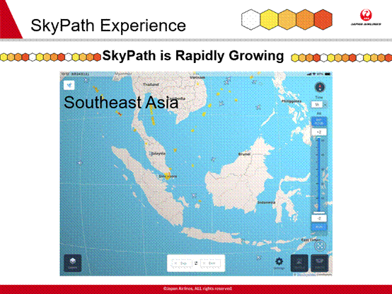
Figure 4.5 – Note: this coverage represents mid 2024 (current coverage improved dramatically)
In this APAC region, when we’re flying to Philippines, Vietnam, Taiwan and down to, Indonesia, Malaysia and Singapore, readers can see there’s not much data being shared. We hope that more airlines, perhaps those that readers work for in the region, start to share their own and our data to improve everybody’s turbulence awareness.
USING SKYPATH IN DISPATCH
In figure 5 you can see how we use SkyPath in Dispatch.
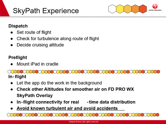
Figure 5
For dispatch, all we have to do is set up the route of flight on the app or Jeppesen FlightDeck Pro with SkyPath weather overlay. We set the route of flight through the app, and then decide the cruising altitude based on the turbulence reported. Then, for pre-flight, all we have to do is set the iPad into the cradle and we’re good to go. That way, when in flight, we just let the app do the work in the background, which means there’s no longer the need to send PIREPS via ACARS. There is no need to communicate; if you have the app, the data will be automatically distributed so that everyone can see it and use it.
The second bullet point there, under ‘in-flight’, is ‘Check other altitudes for smoother air’. When cruising and predicted to encounter light to moderate turbulence, if there are flight attendants doing service in the cabin, we will want to minimize any turbulence and to go to smoother air. It’s now easy to just look on the app and maybe move down a level, or go up a level to reach smoother air, and that’s how we use SkyPath in flight at Japan Airlines.
The most important feature is probably the one at the bottom that says, ‘Avoid known turbulent air…’ If we know that there’s going to be turbulent air and that it cannot be avoided, we know that we have to turn on the seat belt sign. When that seatbelt sign is on; the passengers, flight crew and flight attendants will be seated and belted in and we’re all good to go. Or, if possible, we can change flight levels and avoid that turbulence. If we didn’t have SkyPath, we might not have received that important information ready to use but, with SkyPath, it’s super easy, it’s right there on the iPad.
HOW SKYPATH CHANGED JAL’S MEDIUM-/LONG-HAUL OPERATIONS
For me, because I fly the Boeing 787, we fly long- and medium-haul routes which often, in the context of this article, means having to balance the attributes of different choices. For fuel management purposes, when we’re in the cruise phase, we’re usually at optimum flight levels where we’re saving fuel. But say we encounter moderate turbulence while there are still flight attendants doing service; we want to go lower, but going lower usually means burning more fuel, as figure 6 illustrates.
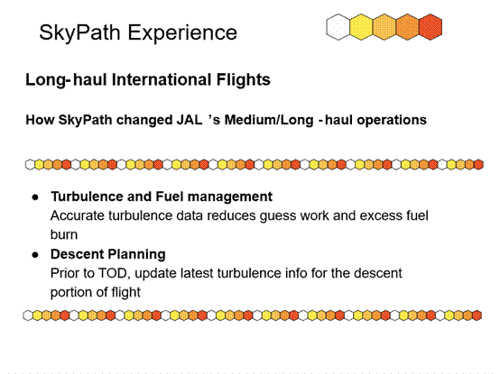
Figure 6
Also, you might not know whether there’s smoother air below you. Then you have to guess whether to go down where you’ll use more fuel plus, what if there might be more turbulence down there. But with SkyPath, there’s no guessing. If you know that there’s smoother air below you, then you’ll know, at that point, to go to that lower level where you’ll burn more fuel but it’ll be safer and more comfortable for passengers.
Japan Airlines also uses SkyPath for descent planning. Prior to the top of descent, usually starting about a half hour before landing time, flight attendants prepare for landing. If it is known that that there’s turbulence during that descent portion of the flight, the pilot can call up the flight attendants to start that pre-landing process 45 minutes or an hour before landing; we can then have the seat belt signs on during the whole of the descent. Traditionally, for long-haul flights, turbulence in the descent portion of the flight is usually based on a 12-hour old forecast that pilots looked at ten hours before the flight. It’s old and not very accurate but, with SkyPath, pilots have real time data, and so know there’s going to be turbulence. That has definitely changed our flying experience.
As far as shorter-haul flights are concerned, a lot of airlines fly domestic or short-/medium-haul one- or two-hour flights. Because the SkyPath information is valid for six hours, even if it’s downloaded on the ground, it will prevent a lot of incidents on such flights, even without having connectivity, which is important to understand.
PILOT FEEDBACK
Japan Airlines has invited and received real feedback from captains on various different aircraft types in the fleet on using SkyPath, as you’ll see in figure 7.
[[INSERT SLIDE 12 HERE]]
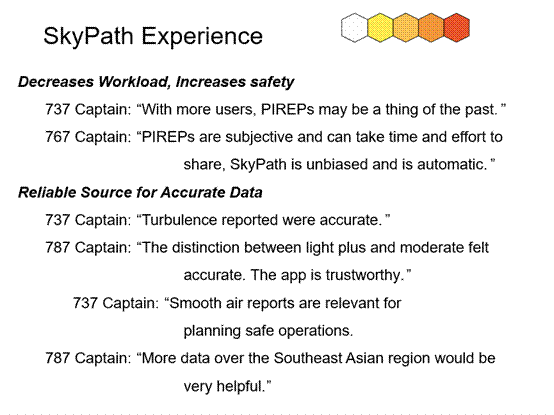
Figure 7
The two main observations were that SkyPath decreases workload and increases safety. On the workload aspect, a Boeing 767, Captain made the comment that PIREPS are subjective and can take time and effort to share. SkyPath is unbiased and is automatic. What that means is, if you’re flying a wide-body like a Boeing 787 or triple seven, and you get a PIREP from a 737 aircraft saying there was moderate turbulence, in the past you had to do a conversion in your head to conclude that moderate turbulence for a 737 might not be that relevant for a larger aircraft; but now, the app will do the conversion on its own; no more guesswork. All the pilot has to do is look at the app and say, ‘okay, there’s moderate turbulence there, so we’ll turn on the seatbelt signs.’
The second part, increasing safety, is about having a reliable source for accurate data. Again, information from other pilots is available through PIREPs but they are subjective; however, the app will do all the calculations on its own so that whatever data is there is relevant and easy to see. Most importantly, and the last one on the figure, a 787 captain said that more data over the Southeast Asia region would be very helpful, which is really a call to other airlines who adopt SkyPath to share more data.
Hagay Makov
CROWDSOURCING TURBULENCE DATA
The biggest secret in the aviation industry is that 79% of turbulence events could be prevented because the information is already listed; however, it’s not always distributed. That’s the most important thing to understand. SkyPath asked customers and prospects to send reports of turbulence incidents they had experienced. In about 79% of cases, the information that would enable the pilot to take management or avoiding action already existed before the event. That means that the amount of turbulence incidents could easily be reduced. As I mentioned, we are not only counting on the pilot to find the location of turbulence, we are actually providing the flight crew with accurate and informed notifications like, ‘In ten minutes, you will hit moderate turbulence so you should stop the cabin service and tell everybody to buckle up seatbelts to prepare for this event.’
That 79 percent figure mentioned above was derived after analyzing hundreds of cases and doing the research to establish did information exist. Whether it’s from observation or our own AI prediction; there is now 12 hours of AI-based prediction available based on the huge number of observations.
Given the recent history for turbulence related incidents and the observed increase in the numbers of such incidents, we hope that this article will help readers who are considering a turbulence solution.
Comments (0)
There are currently no comments about this article.
To post a comment, please login or subscribe.