Articles
| Name | Author | |
|---|---|---|
| Column: The World according to IT and me.. Absolutely Phabulous | Paul Saunders, Solution Manager, Flatirons Solutions | View article |
| Data connectivity for EFBs Part 2 | Bill Vlases, Manager EFB Solutions, Boeing | View article |
| Case Study: Electronic Technical Logbook at Swiss International Airlines | Marcus Di Laurenzio, Technical Project Engineer, SWISS International Airlines, and Udo Stapf, CEO, CrossConsense | View article |
| Aircraft Tracking | Henk Hof, Chairman of ICAO ad-hoc Working Group, Eurocontrol | View article |
Aircraft Tracking
Author: Henk Hof, Chairman of ICAO ad-hoc Working Group, Eurocontrol
SubscribeAircraft Tracking
Henk Hof, Chairman of ICAO ad-hoc Working Group, Eurocontrol explains the Global Aeronautical Distress and Safety System (GADSS)
In light of ICAO’s (International Civil Aviation Organization) recommendation that operators are now required to know the location of each of their aircraft at least once every 15 minutes, this article is about The Global Aeronautical Distress and Safety System (GADSS), the framework for Live Aircraft Tracking, a subject that has become increasingly important in recent years. We’ll look at at the needs, because it’s always important to stay close to the needs when finding solutions; there will also be an overview of GADSS and an update on the current status.
THE NEEDS
We live in a connected society: even just walking down the street, you’ll see people looking at their smart phones, connecting to everywhere in the world, communicating with everyone with whom they want to connect. And that is the experience that the travelling public expects in an aircraft; that it also connects to the world. In that context, saying, ‘we don’t know where an aircraft is’ is not acceptable these days. But, how connected is this aircraft from an Air Traffic Services (ATS) point of view? The answer is: ’It depends‘… there is a gap.
Around the world, there are different levels of air traffic services, different levels of automation, different levels of surveillance quality, different levels of communication and different levels of training. Accordingly, we have different levels of performance, different capacities, different separation standards, etc. to deal with these differences. However, in the event of an emergency, would it be reasonable to say we have different levels of search and rescue performance? No, that would not be reasonable. For search and rescue, and alerting, we need instant and accurate information, instant action, co-ordination and co-operation and we need all that globally… everywhere, at all times. We cannot say that the information is ‘not available here’ or ‘or of less quality’ there; otherwise the performance will also be reduced accordingly. This is the gap that I mentioned above. To close that gap, there’s the need for an overlay of constant and accurate information, for knowing where the aircraft is and knowing when an aircraft is in distress.
When we developed this concept for the global aeronautical distress and safety system, we also looked at our colleagues in the maritime sector where there is no equivalent of air traffic control or traffic services: a vessel leaves the port and, later, arrives at its destination. Because of accidents in that sector, they developed a system called the Global Maritime Distress and Safety System (GMDSs). That is the inspiration for GADSS – we changed the ‘M’ for and ‘A’ for Aeronautical. GMDSS is a comprehensive environment of systems: terrestrial systems, space based systems and ship borne systems, that give precision information, such as when the ship is in distress, and it includes the LRIT (Long Range Identification and Tracking system), a global system with architecture as in figure 1.
Figure 1
LRIT is a distributed system with data centers and data distribution. Vessels send their position to the system twice a day and in case of an abnormal situation that frequency can be increased to once every fifteen minutes. It’s a global system that has been operational for a couple of years and operators can track their vessels wherever they are in the world using this regulated and specified environment. It offered a good starting point for us when looking for solutions to use in the aeronautical sector.
This gap in our emergency handling and SAR capability became painfully obvious through past accidents and two more recent cases; Malaysian 370 and, before that, Air France 447 where it took two years to find the flight data recorder and cockpit voice recorder. With Malaysian 370, the latest update is that 70,000 square kilometers has been searched and the operation is preparing to extend this to 120,000 kilometers. There’s also a financial aspect to it, as the most expensive search operation in history. But, one thing it has done is demonstrate the vulnerability in the system; and the effectiveness of any search and rescue operation is only as strong as the weakest link in the chain. In this case, the vulnerabilities are in the timely identification and location of aircraft in distress, the availability and sharing of valuable information that enables effective search and rescue and effective and regularly trained procedures. There are procedures in annex 11 for ATS (air traffic services) alerting and annex 12 for search and rescue; but these procedures are not always regularly trained. Fortunately, accidents rarely happen, so it’s important to have training at least annually, to make sure that all participants involved in search and rescue and alerting operations are current and proficient in following these procedures.
So, what do we need? It’s very simple: there are four requirements. We need to know where aircraft fly; as I suggested at the start of the article, it’s not acceptable to not know where an aircraft is. We need to know when aircraft are in distress; when there’s a problem with the aircraft we shouldn’t waste time, we need to know that on the ground. We need to enhance the ability to rescue and to recover the flight information from the wreckage and, not least, evidence that will make clear what has happened.
They are our basic requirements. And with these requirements in mind, the ad hoc working group that I chair has looked at search and rescue around the world and at ATS alerting, and has identified a list of improvements that could be made on airborne systems, for example on the ELT (emergency location transmitter), problems, procedures on ATS services, rescue co-ordination, information sharing… and out of that we developed the Global Aeronautical Distress and Safety System (GADSS) concept of operation. A question often asked is ‘could MH370 still happen today?’ The answer is that we don’t know what happened with MH370 and until that information is available, we cannot definitively answer that question; but there are scenarios that could still happen today. There are still areas in the world where aircraft are under procedure control; they give a procedure report via HF; systems can be switched off and the aircraft become invisible.
GLOBAL AERONAUTICAL DISTRESS AND SAFETY SYSTEM (GADSS)
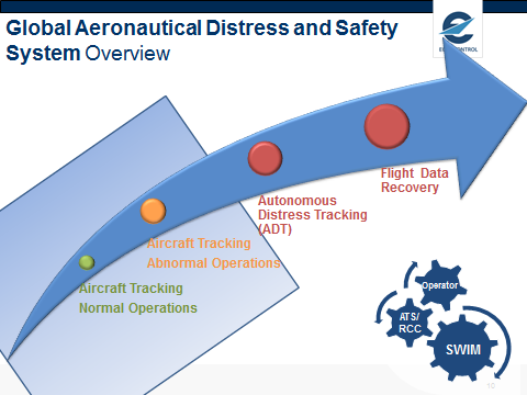
Figure 2
Looking at the various systems involved in the GADSS (see figure 2), the first component is aircraft tracking, the subject in the spotlight today. With aircraft tracking, normal operations, there should be an update once every 15 minutes for aircraft flying in oceanic airspace without automatic surveillance. The same aircraft tracking under the GADSS concept can be used but in abnormal situations (judged ‘abnormal’ according to human judgement) the update rate is increased to once every minute and the information is shared with anyone who might become active in search and rescue and alerting.
The second component is Autonomous Distress Tracking (ADT) when the aircraft is in distress; it’s a triggered transmission at the rate of once every minute so this is activated when there is an actual distress situation – more of that below.
The third component is flight data recovery where there are two possible solutions. One is the automatic deployable flight recorder, mounted on the tail of the aircraft and ejected when there is an impact; the second solution is data streaming
But it’s not only about technology; excellent technology without procedures in place or information sharing is pretty well useless. That’s why GADSS also puts a lot of emphasis on procedures that are symbolized at the bottom right of figure 2. For search and rescue, in ATS alerting there are three basic contributors… the rescue co-ordination center (RCC), the operator and the Air Traffic Service Unit. System Wide Information Management (SWIM) is the environment for sharing information so that information is instantly available. That’s very important; a lot of accidents have revealed the problem that simple information, like telephone numbers, is not immediately available, it has to be looked up whereas the need in a distress or emergency situation is for instant and accurate information.
Looking more closely at Aircraft Tracking, ICAO has finished the standards for the tracking of aircraft (normal and abnormal). The definition in SARPs (standards and recommended practices) is, “A process, established by the operator that maintains and updates at standardized intervals a ground based record of the four dimensional position of individual aircraft in flight”. Importantly, it is an operator’s responsibility to track their aircraft.
The SARPs will be applicable from November 2018 for aircraft with a maximum take-off weight (MTOW) of 45,500 kg and more than 19 seats while for aircraft with MTOW more than 27,000 kg there is a recommendation. This only applies to aircraft flying in oceanic airspace; outside of territorial zones and where there is no other method of ATS surveillance; it is then that the operator needs to track its aircraft.
AIRCRAFT TRACKING WITH AUTOMATED SURVEILLANCE
When flying in an area, like Europe, with automated surveillance or the North Atlantic where there is ADS-C (Automatic Dependent Surveillance – Contract), the aircraft is in contact with an air traffic service unit (ATSU), normal communication, normal automatic surveillance; there’s no requirement for the operator to track its aircraft. That said, several operators do track their aircraft for flight and network operations purposes.
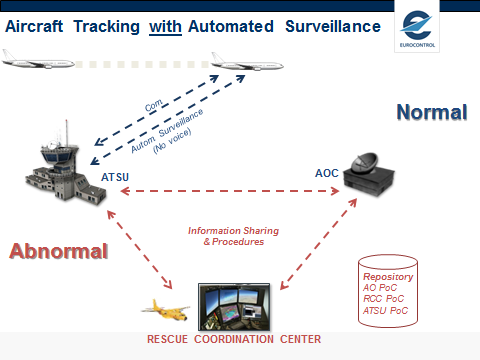
Figure 3
In an abnormal situation, there is sharing of information according to annex 11 and 12 and the operator contacts the rescue co-ordination center. As figure 3 shows, there is also a repository of points of contact in the GADSS. A lot of accidents have revealed that simple telephone numbers of people are difficult to find in the case of operational emergencies, so that was included in the GADSS concept.
AIRCRAFT TRACKING WITHOUT AUTOMATED SURVEILLANCE
When flying in an area without automatic surveillance, such as over the Pacific, the aircraft operator will be obliged to track the aircraft once every 15 minutes with position updates to maintain a record of 4D positions on the ground. In the event of an abnormal situation, the tracking event rate should increase to every minute and the information will be shared with the air traffic service unit and the rescue co-ordination center. What that means in operational terms today, assuming there’s no tracking, is that every hour, in certain areas, the pilot reports his position to the ATSUs (Air Traffic Service Units). So, after an hour, the next update is expected.
But what if, one minute after a pilot’s position report, something happens with the aircraft. The next time the position is expected is 59 minutes after that incident. After those 59 minutes, if everything works well, control on the ground will notice that there has been no new position report and, according to annex 11, there will be a 30 minute period in which ground control will try to contact the aircraft before declaring an emergency. Adding the thirty minutes to the 59 minutes means it is 89 minutes after the incident before an emergency phase is declared (figure 4). All this assumes that everything has gone according to procedures, which is not always the case: there is a lot of complacency in the system because of the generally poor quality of HF communication and because position reports might be at boundary crossings and the controller thinks it might be for the next controller to take action. So, yet more time can elapse before any action is taken.
Figure 4
With normal tracking, that 89 minutes is reduced because the operator tracks the aircraft every 15 minutes so, in our incident scenario above, after 14 minutes, the operator should have a position report and they should also have in place software that will detect missing position reports. Even adding the 30 minutes time for ground control to try to contact the aircraft and it is still only 44 minutes before an emergency phase is declared (figure 5). The 30 minutes ‘contact time’ is a maximum and, in some parts of the world, that has been reduced to 15 minutes which is also a recommendation in the GADSS concept. That’s the operational gain from GADSS.
Figure 5
STANDARDS, RECOMMENDED PRACTICES AND REGULATIONS
Aircraft Tracking is not rocket science, it is quite feasible to track an aircraft today: there’s technology available, there are systems available, there are many examples available of operators tracking their aircraft on a global level – even over polar regions. In the near future, 2017, we have a system Aerion on the horizon that will offer space based ADS-B (Automatic Dependent Surveillance – Broadcast) which will provide tracking services; in short, there’s no reason not to track an aircraft.
In terms of regulation, for the ICAO process, the Standards and Recommended Practices (SARPs) are fairly simple; they are performance based standards (see figure 6) which don’t specify technological solutions, they indicate the ‘once per 15 minutes’ and the applicability timetable, but there are no changes to ATC (air traffic control) procedures.
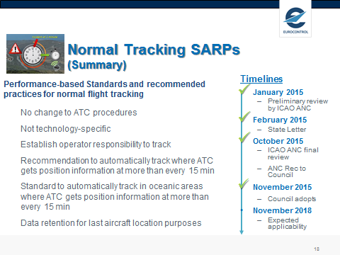
Figure 6
The timeline started in November 2015 with the adoption of proposed ICAO SARPs and an applicability date of 2018. Meanwhile, more guidance material will be developed for operators. The EU regulation is also in progress (currently at draft stage) and is more stringent than the ICAO SARPs; the requirements still relate to 27,000 kg (19 or more seats) and 45,000 kg (no seat number specified so cargo planes included). An important difference is that in the ICAO standards the operator is obliged to track its aircraft only for the portion of the flight in non-surveilled airspace whereas, for the EU regulation, it’s for the whole flight from take-off to landing if the flight is crossing an area of airspace out of automatic surveillance. Also in the EU regulation, while the update rate is 15 minutes until 2021, after January 2021, if the aircraft has no automated means to localize an aircraft accident, the update rate has to increase to once every three minutes.
OTHER COMPONENTS IN GADSS
Autonomous Distress Tracking
Finally, a few words about the other two components in figure 2: in brief they are areas in progress. Autonomous Distress Tracking (ADT) is a vital component (see figure 7). Thinking about the Malaysian case, Malaysian has aircraft tracking but if that is switched off off you don’t see the aircraft; whereas ADT is a device that would be triggered if there was a power failure, for example. An aircraft in distress, according to the GADSS concept, has a number of triggers that have been standardized by EUROCAE (European Organization for Civil Aviation Equipment) and by the ICAO Flight Recorder Panel. Triggers for the transition to autonomous tracking may be activated automatically, manually, or through actions taken on the ground. Trigger examples include unusual attitudes, speed or acceleration, failure of aircraft surveillance and tracking systems, complete loss of engine power or alerts such as ground proximity warnings. These are recoverable conditions so that, if the aircraft recovers, the triggers will be switched off. But if the triggers remain, under distress tracking, the frequency of position reports increases to approximately one minute intervals to ensure that the location of an accident site can be determined to a degree of accuracy within 6 NM (nautical miles). Autonomous Distress Tracking requires new equipment on board the aircraft which is not yet available.
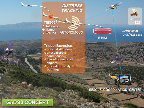
Figure 7
This system works via the Cospas Sarsat system which uses constellations such as Galileo. Autonomous Distress Tracking makes use of the second generation ELT which also can be switched on in flight whereas the older generation of ELT are not detectable when moving.
Deployable Flight Reorder
The third component is the deployable flight recorder. There are investigations taking place on that technology known in the military community but with some nuisance alerts: for instance, it would not be good if, while the aircraft was parked in front of the terminal, the flight recorder ejected and went through the terminal window! Retrieval of flight data can also be accomplished through streaming but with questionable technology capabilities
TIME TO ACT
I’ll close the article with the conclusion that it’s time to act as far as the lessons learned from accidents are concerned. We need to implement these lessons, we need to act. Again, flight tracking is not rocket science, it can be accomplished today and there’s no reason to wait. It’s important to maintain the full scope of GADSS; it’s not only technology or systems but everybody involved needs to train the procedures in being proficient in being able to cope with the unexpected and the improbable. Also very important is information sharing, making sure that when things are happening, you know what to do and you know where to get the information from. And it’s important that communications are conducted in English.
There is, of course, a cost but, as has already been mentioned above, there is no excuse, no possibility to not know where an aircraft is, so this needs to be implemented. And it’s a non-competitive situation, so everybody needs to do it plus there are benefits that can be derived from aircraft tracking for operational purposes. Global harmonization is also a must.
Aviation is safe because it has the culture to react and take lessons out of rare events. That’s why we have a safe industry because we have a strong safety culture which means that, if we know what a lesson is and if we know how to react, we need to react not tomorrow but today so we can take these lessons and we can implement them to make things even safer.
Contributor’s Details
 Henk J. Hof
Henk J. Hof started his professional career in 1985 as policy adviser on communication, navigation and surveillance matters for the Dutch ATC authorities and was a member of the ICAO FANS I and II Committees and ICAO panels. In 1991, he joined EUROCONTROL and is currently Head of the European ATM Master Plan Maintenance Unit. Henk is the EUROCONTROL member and chairman of the ICAO ATM Requirements and Performance Panel (ATMRPP) and chairman of the ICAO Ad-hoc Working Group on Aircraft Tracking.
 Eurocontrol
The European organization for the safety of air navigation, EUROCONTROL’s primary objective is to develop a seamless, pan-European air traffic management (ATM) system that copes with air traffic growth, while maintaining a high level of safety, reducing costs and respecting the environment. EUROCONTROL has 41 Member States.
Comments (0)
There are currently no comments about this article.
To post a comment, please login or subscribe.