TOPLINK: Opening the way to new System Wide Information Services
10 Apr 2015
{{vendor.Name}}
Connect with Aircraft IT
Click here to learn about free Membership to Aircraft IT
TOPLINK: Opening the way to new System Wide Information Services.
TOPLINK, a SESAR* demonstration project led by THALES, is bringing together fourteen European partners to test a new set of services for use in Air Traffic Management (ATM). Taking place in 2015 and 2016, the tests, in live operational conditions on at least 200 flights over Europe and Africa, will aim to demonstrate the benefits for ATM stakeholders (ANSPs, Airlines, Airport operators) of the deployment of a new System Wide Information Services, including Meteorological Services, Aeronautical Information Services, cooperative Network Services, and Flight Information Services (for their non-safety-critical aspects).
The TOPLINK project will demonstrate, based on an end-to-end supporting infrastructure, how Air Traffic Flow Management Controllers, Airport operators, and Commercial Airlines staff (ground Flight Dispatchers, as well as Pilots) could improve their operational performance (especially in terms of safety, efficiency, and capacity) by the use of those new Information Services.
*SESAR: Single European Sky ATM Research programme
14 partners:
- 3 MET Service Providers members of EUMETNET EIG: Météo-France, German Meteorological Service (DWD and Finnish Meteorological Institute (FMI)
- 4 airlines: Air France, Brussels Airlines, HOP! and Air Corsica
- 3 ANSPs: DSNA, Austrocontrol, Croatia Control
- 1 General Aviation operator: Ecole Nationale de l’Aviation Civile (ENAC)
- 1 Airport: Aéroport de Paris (ADP)
- 2 aeronautical industries: Thales (coordinator), Airbus
The TOPLINK project concept and architecture build on the previous TOPMET Demonstration Project, addressing essentially the use of MET information services, which in turn results in improved flight safety, more accurate information for flight planning, and enhanced flight efficiency and airspace capacity.
The objectives are to develop the concept and accelerate its operational deployment within 2 years, particularly through a continued and permanent connectivity between the ground and the cockpit, thanks to satellite communications. Information shared with the pilot will be displayed on an EFB mobile and connected in real time by SATCOM.
TOPLINK also provides an avenue to deeply engage in the joint development of a new Local DCB tool to support FMP operations and to achieve significant progress towards collaborative operations with Airlines and Airport operators.
Illustrations Examples of MET information superimposed on aircraft operational flight plan and ATM information. Copyright ©TOPMET 2014
Contact: daniel.muller@thalesgroup.com
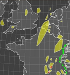
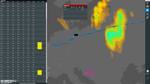
Extract from Pilot Extract from ANSPs or AOC tool