Optimized flight operations: Lufthansa Systems integrates new weather display feature in navigation solution
02 May 2019
{{vendor.Name}}
Connect with Aircraft IT
Click here to learn about free Membership to Aircraft IT
Optimized flight operations: Lufthansa Systems integrates new weather display feature in navigation solution
Digital weather display improves safety and efficiency | New feature in latest version of Lido/eRouteManual 5.0
Raunheim, May 2, 2019 – Lufthansa Systems today announced the integration of the new feature with the name “Weather” in its Lido/eRouteManual navigation solution. Weather phenomena can now be downloaded and displayed on enroute navigation maps without needing to install additional software. Text-based weather information is also available for every airport. With the introduction of the new Version 5.0 of Lido/eRouteManual, this weather data is just a few clicks away.
“Relevant meteorological information is in high demand among airlines, including our customers. Hardly anything has more negative effects on flight operations than the weather. Together with our customer Lufthansa, we developed the Weather feature to display current weather data on our maps,” explained Dr. Bernd Jurisch, Head of Flight & Navigation Products & Solutions at Lufthansa Systems. “The updated Version 5.0 of Lido/eRouteManual seamlessly integrates the new feature. The smart and reliable Weather feature enables pilots to access the necessary weather information more quickly and choose the best route based on the weather conditions.”
Lido/eRouteManual Weather from Lufthansa Systems includes weather information that the pilots receive digitally in text form during their briefing at the airport. The visualization of weather phenomena such as storm cells, cloud heights and turbulence optimally supports the preparations of the flight deck crew. This saves time, lowers the risk of delays and increases safety.
Airlines using the Lido/eRouteManual Weather feature receive live weather updates every five minutes. Displaying current weather data on the navigation maps improves the pilots’ situational awareness and helps them make tactical decisions during a flight. The ability to avoid turbulence also increases passenger comfort.
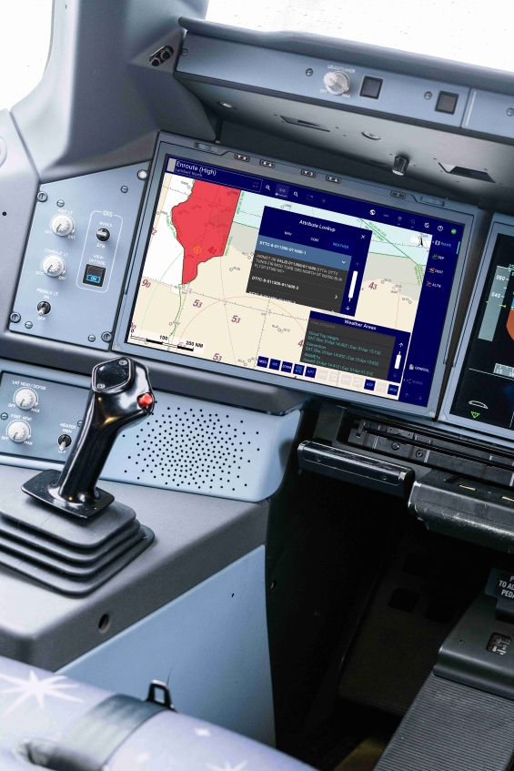
The Lido/eRouteManual navigation solution from Lufthansa Systems has been expanded to include a new feature with the name “Weather”. The digital weather feature optimizes flight preparations and displays the current weather directly in the enroute chart.
Lido/eRouteManual is the Windows-based digital version of the navigation maps and has already been deployed by more than 50 airlines worldwide. The application includes navigation maps for take-off and landing procedures as well as enroute charts that comprise all important route information like altitude data and airport features. These maps are generated directly from the Lido/FMS navigation database, which includes worldwide aeronautical information. Lido/eRouteManual supports all well-known Avionics interfaces as well as commercially available GPS receivers for displaying the current aircraft position on enroute and terminal maps. The app’s Lido/AMM module provides high-precision airport moving maps that facilitate navigation for pilots during taxi operations.
Icelandair has already successfully tested Lido/eRouteManual Weather in practice. “For flights in our transatlantic network and in charter operations worldwide, the ability to provide our pilots with live weather updates from Lido/eRouteManual equips them with a new tool to make better decisions in order to avoid bad weather. This saves fuel, reduces CO2 emissions, improves passenger comfort and reduces the risk of delays,” said Grétar Mar Óðinsson, EFB Administrator at Icelandair. “We are very pleased with Lido/eRouteManual from Lufthansa Systems overall. The new weather feature impressed us not least because it directly addresses the needs of Icelandair.”
The weather information in Lido/eRouteManual is based on data provided by the US engineering firm Basic Commerce and Industries (BCI). The text-based weather information provided at airports and covering significant meteorological events comes from Lufthansa Systems’ own database for its Lido/Flight 4D route planning solution.
Further images can be found in the download section of our website at: