Eagle Cap Software Announces the Release of Aviation Charting Service
29 Mar 2017
{{vendor.Name}}
Connect with Aircraft IT
Click here to learn about free Membership to Aircraft IT
Eagle Cap Software Announces the Release of Aviation Charting Service
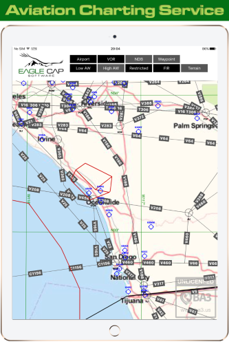
Sherwood, OR—February 7, 2017— Aviation Charting Service (ACS) by Eagle Cap Software includes the tools and software necessary for application developers to add an aeronautical chart display—based on ARINC 424 data—to their application. Previously this required writing custom code in addition to the monthly chore of processing the data.
According to Dane Winchester, Co-Founder of Eagle Cap Software, “Aviation Charting Service renders ARINC 424 data as vector elements from an SQLite database, minimizing the footprint of the data and increasing load times.”
Aviation Charting Service also supports raster tiles for the display of cultural, terrain, weather, or other data. The service consists of two components: 1) a library to display the data, and 2) an ARINC 424 data converter. Eagle Cap Software will also offer an ARINC 424 data subscription to application developers, eliminating the need to contract yet another service.
Aviation Charting Service currently supports the following ARINC 424 data types: Airports, VORs, NDBs, Waypoints, Airways (High), Airways (Low), Restricted Airspace, and FIRs.
“This service provides a quick and easy method for application developers to add the visualization of aviation data to their application’s map display,” said Winchester.
Aviation Charting Service is available for integration into iOS and web applications. Application developers can contact Eagle Cap Software for technical details and to schedule demo.