AVTECH’s partnership with the Met Office sets a new gold standard in flight optimization
23 Jan 2026
{{vendor.Name}}
Connect with Aircraft IT
Sign up to the Aircraft IT twitter feed for all the aviation industry's latest IT related news
Click here to learn about free Membership to Aircraft IT
As aviation faces mounting challenges from climate change, fuel efficiency demands, and an increase in turbulence events, one partnership is redefining how airlines can navigate the skies more safely and sustainably.
AVTECH Sweden AB collaborates directly with the UK Met Office, a global authority in meteorology now powered by a new supercomputer. This technological leap will enable more accurate and higher-resolution weather forecasts than ever before – crucial for predicting complex phenomena such as clear-air turbulence, storm systems, and jet-stream shifts.
AI-Enhanced Forecasting: The Future of Weather Intelligence

The Met Office’s transition to a cloud-based supercomputer infrastructure represents a major step forward in meteorological science. With machine learning and AI techniques embedded in the forecasting process, this system analyses over 50 billion weather observations daily, providing the ability to model atmospheric dynamics at ultra-fine scales.
According to the Met Office, future AI-driven capabilities will continue to sharpen forecasts of complex weather patterns, potentially providing better understanding of evolving turbulence layers and developing storm cells. This improved capability would give pilots and flight planners earlier, more precise warnings and optimization opportunities.
These advances will directly enhance AVTECH’s suite of real-time flight optimization tools, which leverage the Met Office’s high-resolution (10 km) model, surpassing the industry standard of 140 kilometre and 3-hourly.
AVTECH + Met Office: Turning Forecasting Power into Operational Advantage
AVTECH turns Met Office’s raw numerical weather forecasts and translate them into actionable, flight-specific guidance and services tailored to fit each airline. Rather than presenting pilots or dispatchers with generic weather maps, AVTECH processes high-resolution forecast data along each individual flight’s four-dimensional trajectory: latitude, longitude, altitude and time. These tailored forecasts are then integrated into flight planning systems, pilot briefing tools and directly into the aircraft’s Flight Management Computer. Rather than presenting pilots or dispatchers with generic weather maps, AVTECH processes high-resolution forecast data along each individual flight’s four-dimensional trajectory: latitude, longitude, altitude and time. These tailored forecasts are then integrated into flight planning systems, pilot briefing tools and directly into the aircraft’s Flight Management Computer.
The result is practical decision support for pilots and airline flight operations: optimized flight levels, more accurate time and fuel predictions, and improved awareness of turbulence and hazardous weather.

![]()
“One of our most prominent commercial features is our partnership with AVTECH Sweden AB. The Swedish software company and the Met Office provide flight optimisation services that help pilots avoid turbulence through real-time route adjustments based on live weather data.” — Lauren Donohue, Aviation Business Manager at the Met Office
Why the Met Office’s “Optimal Blend” Is So Exciting for Aviation
From AVTECH’s perspective, the partnership with the Met Office was always driven by one core requirement: access to the most accurate, high-resolution weather data available for aviation operations. Independent analysis of tens of thousands of flights has consistently shown that higher-resolution wind and temperature forecasts significantly reduce forecast error compared with standard, coarse-grid aviation weather products. That accuracy directly underpins safer, more efficient flight operations, better fuel planning and more reliable decision-making for pilots and airlines.
Today, that value proposition is being taken even further as the Met Office invests in next-generation forecasting science — including its transition to a powerful cloud-based supercomputer and its development of what it calls an “optimal blend” of physics-based and machine-learning approaches to weather prediction.
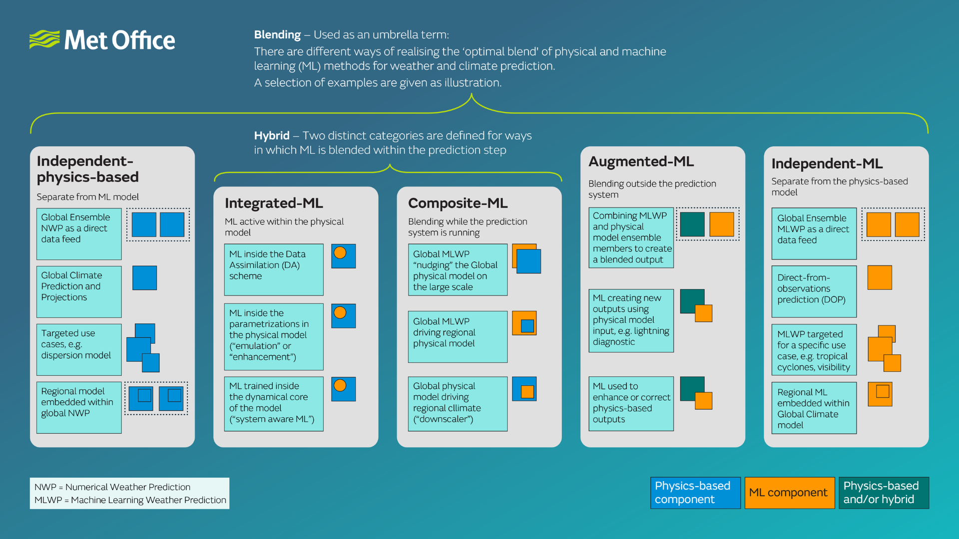
The Met Office’s concept of an “optimal blend” reflects a strategic shift in how forecasts are produced. Traditional physics-based numerical weather prediction remains the backbone of forecasting, using fundamental equations of atmospheric motion that are trusted, explainable and physically consistent. Machine-learning approaches, by contrast, learn patterns from vast archives of data and can produce forecasts or enhancements far more quickly. Rather than choosing one over the other, the Met Office is actively exploring how to combine them, through hybrid and augmented approaches, to extract the best qualities of both.
For aviation, this has several important implications:
Speed and timeliness. Machine-learning components can dramatically reduce computation time or post-processing delays, enabling more frequent forecast updates. In an operational aviation context, faster access to updated wind, temperature or convective information improves situational awareness for time-critical decisions such as route adjustments, altitude changes or departure and arrival planning.
Accuracy and uncertainty handling. Machine learning can help correct systematic biases or refine outputs from physics-based models using real-world patterns, while physics ensures robustness during rare or extreme events. For airlines, even marginal improvements in forecast precision can reduce unnecessary fuel burn from weather deviations, improve turbulence and icing alerts, and support more confident operational decisions.
Richer use of diverse data sources. AI and ML methods excel at ingesting large volumes of heterogeneous data — including satellite observations, radar and aircraft-generated data. The Met Office is already making increasing use of aircraft observations within its modelling systems, creating a virtuous cycle where aviation data contributes to better forecasts, which in turn support better flight operations.
Tailored and scalable forecast products. The blended approach opens the door to more aviation-specific indices, probabilistic outputs or statistically tuned products designed around real operational needs rather than generic weather parameters. For AVTECH, this creates opportunities to deliver even more aviation-centric decision support, differentiated by relevance and usability rather than raw data volume.
Turning Better Forecasts into Safer Skies
These advances in weather modelling have a direct bearing on one of aviation’s most persistent challenges: turbulence. As the Met Office’s forecasting capabilities evolve, AVTECH translates that enhanced precision into practical hazard detection that crews can act on.
Clear-air turbulence, in particular, has long been difficult to anticipate. It forms in fine-scale atmospheric structures—wind shear zones, jet-stream boundaries and stability gradients—that standard forecasts often fail to resolve. Higher-resolution modelling, combined with AVTECH’s advanced post-processing, now makes it possible to identify turbulence-prone regions along a flight’s specific trajectory, shifting the approach from reactive response to proactive avoidance.
How AVTECH Detects All Major Turbulence Types
By leveraging the Met Office’s high-resolution data and integrating real-time observational feeds, AVTECH provides pilots with precise, flight-specific alerts for every significant turbulence category:
- •Clear Air Turbulence (CAT): Invisible to onboard radar and occurring in cloudless skies, CAT is notoriously difficult to detect. AVTECH identifies CAT-prone regions using forecast wind shear and stability data, giving crews the advance warning needed to adjust altitude or secure the cabin before passengers are at risk.
- •Mountain Wave Turbulence: When stable air flows over mountainous terrain, it can generate powerful waves that propagate to cruising altitudes—often far from the mountains themselves. AVTECH’s detection services identify these patterns, helping pilots steer clear of the downdrafts and rotors that make mountain wave encounters particularly hazardous.
- •Convective Turbulence (CB): Additionally, AVTECH has the capability to detect convective turbulence associated with thunderstorms and cumulonimbus clouds—some of the most severe turbulence pilots encounter. Through Cb-Global integration, AVTECH’s ProFlight delivers real-time convective alerts, enabling proactive routing around developing storm cells.
Together, these capabilities illustrate how the AVTECH–Met Office partnership extends beyond route optimization. By transforming forecast intelligence into actionable hazard awareness, the collaboration helps airlines protect passengers and crew while maintaining the efficiency gains that drive their operations.
Looking Ahead
Over the next five to ten years, the relationship between advanced weather modelling and flight optimisation is likely to deepen further. As forecast resolution increases, update cycles shorten and AI-enhanced methods mature, weather data will become even more tightly embedded in both strategic planning and real-time flight operations. For airlines, this means not just incremental efficiency gains, but a shift toward continuous, weather-aware optimisation that supports safety, sustainability and operational resilience.
For AVTECH, continued collaboration with the Met Office ensures access to the forefront of atmospheric science — enabling the translation of cutting-edge forecasting innovation into practical tools that pilots and airlines can trust, understand and use every day.